


131-Lablachere_PontMegalithique

ganinette
User
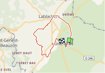

Length
7.2 km
Boucle
Yes
Creation date :
2024-12-18 08:19:01.02
Updated on :
2024-12-18 08:19:01.02
--
Difficulty : Unknown

FREE GPS app for hiking
 SityTrail
IGN / Geographical institutes
SityTrail Plus
The world is yours!
About
Trail Walking of 7.2 km to be discovered at Auvergne-Rhône-Alpes, Ardèche, Lablachère. This trail is proposed by ganinette.


Positioning
Country:
France
Region :
Auvergne-Rhône-Alpes
Department/Province :
Ardèche
Municipality :
Lablachère
Location:
Unknown
Start:(Dec)
Start:(UTM)
597325 ; 4922828 (31T) N.
Comments