


20241218€_€'

Jeanclaudebic
User
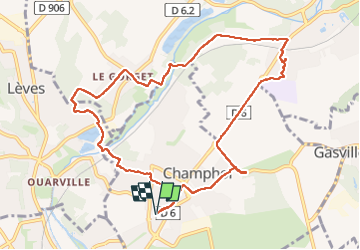

Length
10.4 km

Max alt
158 m

Uphill gradient
93 m
Km-Effort
11.6 km

Min alt
117 m

Downhill gradient
93 m
Boucle
Yes
Creation date :
2024-12-18 13:02:37.73
Updated on :
2024-12-18 15:24:50.974
2h21
Difficulty : Medium

FREE GPS app for hiking
 SityTrail
IGN / Geographical institutes
SityTrail Plus
The world is yours!
About
Trail Walking of 10.4 km to be discovered at Centre-Loire Valley, Eure-et-Loir, Champhol. This trail is proposed by Jeanclaudebic.
Positioning
Country:
France
Region :
Centre-Loire Valley
Department/Province :
Eure-et-Loir
Municipality :
Champhol
Location:
Unknown
Start:(Dec)
Start:(UTM)
389203 ; 5368947 (31U) N.
Comments