


Footing Lesquin

topolino
User
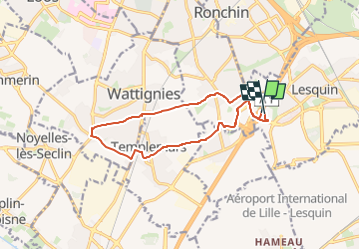

Length
11.6 km

Max alt
61 m

Uphill gradient
65 m
Km-Effort
12.5 km

Min alt
24 m

Downhill gradient
65 m
Boucle
Yes
Creation date :
2024-12-19 15:24:10.0
Updated on :
2024-12-19 15:24:11.658
0m
Difficulty : Medium

FREE GPS app for hiking
 SityTrail
IGN / Geographical institutes
SityTrail Plus
The world is yours!
About
Trail Running of 11.6 km to be discovered at Hauts-de-France, Nord, Lesquin. This trail is proposed by topolino.
Positioning
Country:
France
Region :
Hauts-de-France
Department/Province :
Nord
Municipality :
Lesquin
Location:
Unknown
Start:(Dec)
Start:(UTM)
506495 ; 5603537 (31U) N.
Comments