


Chuel montagnards Limonest

ophness
User
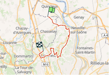

Length
23 km

Max alt
593 m

Uphill gradient
713 m
Km-Effort
32 km

Min alt
182 m

Downhill gradient
557 m
Boucle
No
Creation date :
2024-12-21 21:29:28.0
Updated on :
2024-12-21 21:29:29.11
4h09
Difficulty : Difficult

FREE GPS app for hiking
 SityTrail
IGN / Geographical institutes
SityTrail Plus
The world is yours!
About
Trail Horseback riding of 23 km to be discovered at Auvergne-Rhône-Alpes, Rhône, Chasselay. This trail is proposed by ophness.
Positioning
Country:
France
Region :
Auvergne-Rhône-Alpes
Department/Province :
Rhône
Municipality :
Chasselay
Location:
Unknown
Start:(Dec)
Start:(UTM)
637274 ; 5084192 (31T) N.
Comments