


Methamis Family Trek

supercolas
User GUIDE
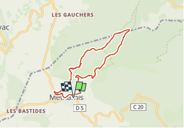

Length
8.1 km

Max alt
463 m

Uphill gradient
291 m
Km-Effort
12 km

Min alt
263 m

Downhill gradient
291 m
Boucle
Yes
Creation date :
2024-12-27 10:38:58.861
Updated on :
2024-12-27 17:35:31.706
2h30
Difficulty : Medium

FREE GPS app for hiking
 SityTrail
IGN / Geographical institutes
SityTrail Plus
The world is yours!
About
Trail Walking of 8.1 km to be discovered at Provence-Alpes-Côte d'Azur, Vaucluse, Méthamis. This trail is proposed by supercolas.
Description
Méthamis
Positioning
Country:
France
Region :
Provence-Alpes-Côte d'Azur
Department/Province :
Vaucluse
Municipality :
Méthamis
Location:
Unknown
Start:(Dec)
Start:(UTM)
678294 ; 4875752 (31T) N.
Comments