


2025 Queyras J03

Airelle
User
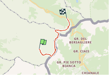

Length
7.8 km

Max alt
3029 m

Uphill gradient
675 m
Km-Effort
16.5 km

Min alt
2498 m

Downhill gradient
599 m
Boucle
No
Creation date :
2024-12-29 09:26:01.137
Updated on :
2024-12-29 10:57:15.432
3h45
Difficulty : Easy

FREE GPS app for hiking
 SityTrail
IGN / Geographical institutes
SityTrail Plus
The world is yours!
About
Trail On foot of 7.8 km to be discovered at Provence-Alpes-Côte d'Azur, Hautes-Alpes, Saint-Véran. This trail is proposed by Airelle.
Positioning
Country:
France
Region :
Provence-Alpes-Côte d'Azur
Department/Province :
Hautes-Alpes
Municipality :
Saint-Véran
Location:
Unknown
Start:(Dec)
Start:(UTM)
336749 ; 4947957 (32T) N.
Comments