


La Lieutenante (D.R )

mb83serre
User GUIDE
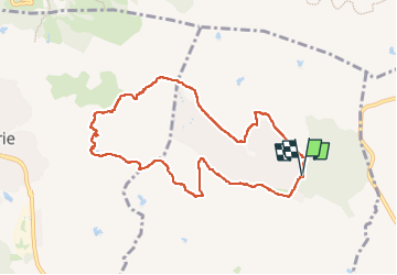

Length
9.3 km

Max alt
108 m

Uphill gradient
107 m
Km-Effort
10.7 km

Min alt
54 m

Downhill gradient
109 m
Boucle
Yes
Creation date :
2024-12-30 07:43:44.745
Updated on :
2024-12-30 14:03:10.773
2h46
Difficulty : Easy

FREE GPS app for hiking
 SityTrail
IGN / Geographical institutes
SityTrail Plus
The world is yours!
About
Trail Walking of 9.3 km to be discovered at Provence-Alpes-Côte d'Azur, Var, Puget-sur-Argens. This trail is proposed by mb83serre.
Photos
 - Photo 1")
 - Photo 2")
 - Photo 3")
 - Photo 4")
Positioning
Country:
France
Region :
Provence-Alpes-Côte d'Azur
Department/Province :
Var
Municipality :
Puget-sur-Argens
Location:
Unknown
Start:(Dec)
Start:(UTM)
313728 ; 4818557 (32T) N.
Comments