


rando tour d'Atger

Dan030
User
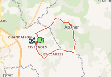

Length
7.2 km

Max alt
1111 m

Uphill gradient
151 m
Km-Effort
9.2 km

Min alt
1017 m

Downhill gradient
146 m
Boucle
Yes
Creation date :
2024-12-30 13:15:25.715
Updated on :
2024-12-30 15:54:35.688
2h38
Difficulty : Medium

FREE GPS app for hiking
 SityTrail
IGN / Geographical institutes
SityTrail Plus
The world is yours!
About
Trail Walking of 7.2 km to be discovered at Occitania, Lozère, Saint-Chély-d'Apcher. This trail is proposed by Dan030.
Positioning
Country:
France
Region :
Occitania
Department/Province :
Lozère
Municipality :
Saint-Chély-d'Apcher
Location:
Unknown
Start:(Dec)
Start:(UTM)
523954 ; 4961655 (31T) N.
Comments