


Bois de la Civadière

JMJ42
User
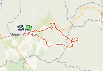

Length
15 km

Max alt
324 m

Uphill gradient
151 m
Km-Effort
17 km

Min alt
284 m

Downhill gradient
151 m
Boucle
Yes
Creation date :
2024-12-30 16:55:05.45
Updated on :
2024-12-30 16:55:50.02
3h52
Difficulty : Medium

FREE GPS app for hiking
 SityTrail
IGN / Geographical institutes
SityTrail Plus
The world is yours!
About
Trail Walking of 15 km to be discovered at Occitania, Gard, Méjannes-le-Clap. This trail is proposed by JMJ42.
Positioning
Country:
France
Region :
Occitania
Department/Province :
Gard
Municipality :
Méjannes-le-Clap
Location:
Unknown
Start:(Dec)
Start:(UTM)
607800 ; 4897769 (31T) N.
Comments