


boverie

PatriceCocuaud
User
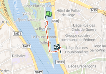

Length
557 m

Max alt
72 m

Uphill gradient
4 m
Km-Effort
613 m

Min alt
64 m

Downhill gradient
5 m
Boucle
No
Creation date :
2024-12-30 14:42:16.208
Updated on :
2024-12-30 18:47:40.272
8m
Difficulty : Very easy

FREE GPS app for hiking
 SityTrail
IGN / Geographical institutes
SityTrail Plus
The world is yours!
About
Trail Walking of 557 m to be discovered at Wallonia, Liège, Liège. This trail is proposed by PatriceCocuaud.
Positioning
Country:
Belgium
Region :
Wallonia
Department/Province :
Liège
Municipality :
Liège
Location:
Unknown
Start:(Dec)
Start:(UTM)
682314 ; 5611605 (31U) N.
Comments