


tulette

gero2b
User
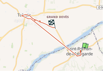

Length
6.2 km

Max alt
191 m

Uphill gradient
64 m
Km-Effort
7.1 km

Min alt
140 m

Downhill gradient
83 m
Boucle
No
Creation date :
2024-12-04 06:05:43.484
Updated on :
2024-12-31 07:53:02.482
2h44
Difficulty : Very easy

FREE GPS app for hiking
 SityTrail
IGN / Geographical institutes
SityTrail Plus
The world is yours!
About
Trail Car of 6.2 km to be discovered at Provence-Alpes-Côte d'Azur, Vaucluse, Saint-Roman-de-Malegarde. This trail is proposed by gero2b.
Positioning
Country:
France
Region :
Provence-Alpes-Côte d'Azur
Department/Province :
Vaucluse
Municipality :
Saint-Roman-de-Malegarde
Location:
Unknown
Start:(Dec)
Start:(UTM)
656791 ; 4903777 (31T) N.
Comments