


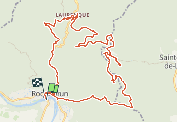
Roquebrun - Laurenque - Ermitage St Etienne

Bart2015
User


5h51
Difficulty : Very difficult

FREE GPS app for hiking
 SityTrail
IGN / Geographical institutes
SityTrail Plus
The world is yours!
About
Trail Walking of 17.2 km to be discovered at Occitania, Hérault, Roquebrun. This trail is proposed by Bart2015.
Description
Randonnée au départ de Roquebrun menant à l'ancien Ermitage St Etienne fondé au 12è siècle. Passage près du beau village de Laurenque. Depuis l'ermitage, lle panorama est magnifique. Sous l'ermitage, une carrière de marbre rose typique de la région et exploitées à partir du 17è siècle.
Petite visite du beau village au retour et peut-être une dégustation chez un viticulteur, Thierry Navarre par exemple ...
Bonne rando, soyez prudent ...
Photos


Positioning
Comments