


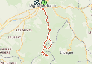
Digne gassendi cousson 1060m 18kms

Danielba
User GUIDE

Length
16.9 km

Max alt
1492 m

Uphill gradient
966 m
Km-Effort
30 km

Min alt
594 m

Downhill gradient
967 m
Boucle
Yes
Creation date :
2025-01-01 07:58:24.961
Updated on :
2025-01-01 18:38:00.139
7h57
Difficulty : Medium

FREE GPS app for hiking
 SityTrail
IGN / Geographical institutes
SityTrail Plus
The world is yours!
About
Trail Walking of 16.9 km to be discovered at Provence-Alpes-Côte d'Azur, Alpes-de-Haute-Provence, Digne-les-Bains. This trail is proposed by Danielba .
Photos


Positioning
Country:
France
Region :
Provence-Alpes-Côte d'Azur
Department/Province :
Alpes-de-Haute-Provence
Municipality :
Digne-les-Bains
Location:
Unknown
Start:(Dec)
Start:(UTM)
278398 ; 4885491 (32T) N.
Comments