


Lac de Soum

chasle
User
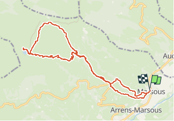

Length
12.8 km

Max alt
1539 m

Uphill gradient
704 m
Km-Effort
22 km

Min alt
860 m

Downhill gradient
704 m
Boucle
Yes
Creation date :
2025-01-02 08:02:17.095
Updated on :
2025-01-02 16:12:03.461
3h36
Difficulty : Difficult

FREE GPS app for hiking
 SityTrail
IGN / Geographical institutes
SityTrail Plus
The world is yours!
About
Trail Walking of 12.8 km to be discovered at Occitania, Hautespyrenees, Arrens-Marsous. This trail is proposed by chasle.
Positioning
Country:
France
Region :
Occitania
Department/Province :
Hautespyrenees
Municipality :
Arrens-Marsous
Location:
Unknown
Start:(Dec)
Start:(UTM)
728186 ; 4760689 (30T) N.
Comments