


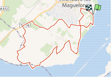
Les Salins de Villeneuve les Maguelone

ARVIEU
User

Length
14.1 km

Max alt
19 m

Uphill gradient
66 m
Km-Effort
15 km

Min alt
-3 m

Downhill gradient
66 m
Boucle
Yes
Creation date :
2025-01-02 17:03:57.12
Updated on :
2025-01-02 17:04:54.278
4h00
Difficulty : Easy

FREE GPS app for hiking
 SityTrail
IGN / Geographical institutes
SityTrail Plus
The world is yours!
About
Trail Walking of 14.1 km to be discovered at Occitania, Hérault, Villeneuve-lès-Maguelone. This trail is proposed by ARVIEU.
Positioning
Country:
France
Region :
Occitania
Department/Province :
Hérault
Municipality :
Villeneuve-lès-Maguelone
Location:
Unknown
Start:(Dec)
Start:(UTM)
570531 ; 4819787 (31T) N.
Comments