


Sauvenière

PatriceCocuaud
User
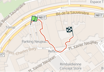

Length
214 m

Max alt
72 m

Uphill gradient
3 m
Km-Effort
244 m

Min alt
68 m

Downhill gradient
0 m
Boucle
Yes
Creation date :
2025-01-02 17:41:05.264
Updated on :
2025-01-02 17:53:35.36
12m
Difficulty : Very easy

FREE GPS app for hiking
 SityTrail
IGN / Geographical institutes
SityTrail Plus
The world is yours!
About
Trail Walking of 214 m to be discovered at Wallonia, Liège, Liège. This trail is proposed by PatriceCocuaud.
Positioning
Country:
Belgium
Region :
Wallonia
Department/Province :
Liège
Municipality :
Liège
Location:
Grivegnée
Start:(Dec)
Start:(UTM)
681495 ; 5613357 (31U) N.
Comments