


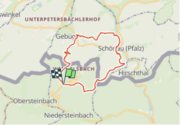
Wasigenstein Schönau 13 km BS

bstebe
User

Length
12.9 km

Max alt
446 m

Uphill gradient
454 m
Km-Effort
19 km

Min alt
213 m

Downhill gradient
449 m
Boucle
Yes
Creation date :
2025-01-03 17:12:24.007
Updated on :
2025-01-03 17:13:30.229
4h18
Difficulty : Difficult

FREE GPS app for hiking
 SityTrail
IGN / Geographical institutes
SityTrail Plus
The world is yours!
About
Trail Walking of 12.9 km to be discovered at Grand Est, Bas-Rhin, Niedersteinbach. This trail is proposed by bstebe.
Positioning
Country:
France
Region :
Grand Est
Department/Province :
Bas-Rhin
Municipality :
Niedersteinbach
Location:
Unknown
Start:(Dec)
Start:(UTM)
405618 ; 5433133 (32U) N.
Comments