


à côté de Velaux

taguette
User
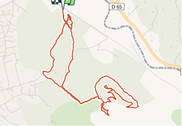

Length
7.8 km

Max alt
228 m

Uphill gradient
170 m
Km-Effort
10 km

Min alt
77 m

Downhill gradient
171 m
Boucle
Yes
Creation date :
2025-01-04 09:02:56.423
Updated on :
2025-01-04 11:38:17.846
2h35
Difficulty : Medium

FREE GPS app for hiking
 SityTrail
IGN / Geographical institutes
SityTrail Plus
The world is yours!
About
Trail Walking of 7.8 km to be discovered at Provence-Alpes-Côte d'Azur, Bouches-du-Rhône, Velaux. This trail is proposed by taguette.
Positioning
Country:
France
Region :
Provence-Alpes-Côte d'Azur
Department/Province :
Bouches-du-Rhône
Municipality :
Velaux
Location:
Unknown
Start:(Dec)
Start:(UTM)
683453 ; 4822580 (31T) N.
Comments