


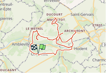
Balade autour de Omerville

alainchardon
User

Length
24 km

Max alt
166 m

Uphill gradient
427 m
Km-Effort
30 km

Min alt
48 m

Downhill gradient
424 m
Boucle
Yes
Creation date :
2025-01-04 14:12:56.971
Updated on :
2025-01-04 17:30:58.984
1h56
Difficulty : Medium

FREE GPS app for hiking
 SityTrail
IGN / Geographical institutes
SityTrail Plus
The world is yours!
About
Trail Mountain bike of 24 km to be discovered at Ile-de-France, Val-d'Oise, Omerville. This trail is proposed by alainchardon.
Positioning
Country:
France
Region :
Ile-de-France
Department/Province :
Val-d'Oise
Municipality :
Omerville
Location:
Unknown
Start:(Dec)
Start:(UTM)
406431 ; 5443883 (31U) N.
Comments