


murs grottes de Berigoule combe de la rouquette
© OpenStreetMap contributors


3h44
Difficulty : Medium


Length
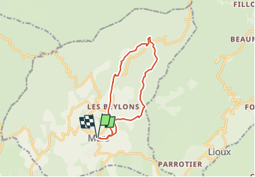
12 km
Max alt
696 m
Uphill gradient
337 m
Km-Effort
16.4 km
Min alt
447 m
Downhill gradient
336 m
Boucle
Yes
Creation date :
2025-01-04 17:31:54.81
Updated on :
2025-01-23 07:00:11.755
3h44
Difficulty : Medium
FREE GPS app for hiking
 SityTrail
IGN / Geographical institutes
SityTrail Plus
The world is yours!
About
Trail Walking of 12 km to be discovered at Provence-Alpes-Côte d'Azur, Vaucluse, Murs. This trail is proposed by les joyeux randonneurs.
Positioning
Country:
France
Region :
Provence-Alpes-Côte d'Azur
Department/Province :
Vaucluse
Municipality :
Murs
Location:
Unknown
Start:(Dec)
Start:(UTM)
679917 ; 4868927 (31T) N.
Comments