


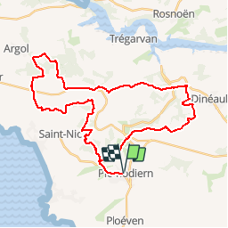
PLOMODIERN ARGOL

aderas
User

Length
39 km

Max alt
223 m

Uphill gradient
820 m
Km-Effort
50 km

Min alt
29 m

Downhill gradient
821 m
Boucle
Yes
Creation date :
2015-06-08 00:00:00.0
Updated on :
2015-06-08 00:00:00.0
3h00
Difficulty : Medium

FREE GPS app for hiking
 SityTrail
IGN / Geographical institutes
SityTrail Plus
The world is yours!
About
Trail Mountain bike of 39 km to be discovered at Brittany, Finistère, Plomodiern. This trail is proposed by aderas.
Positioning
Country:
France
Region :
Brittany
Department/Province :
Finistère
Municipality :
Plomodiern
Location:
Unknown
Start:(Dec)
Start:(UTM)
408303 ; 5337220 (30U) N.
Comments