


Aurons

taguette
User
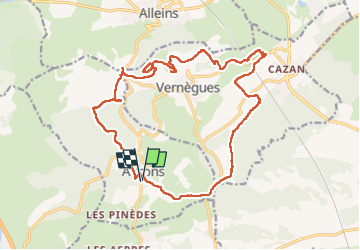

Length
21 km

Max alt
387 m

Uphill gradient
446 m
Km-Effort
27 km

Min alt
170 m

Downhill gradient
445 m
Boucle
Yes
Creation date :
2025-01-05 07:30:50.014
Updated on :
2025-01-05 13:41:57.463
6h09
Difficulty : Very difficult

FREE GPS app for hiking
 SityTrail
IGN / Geographical institutes
SityTrail Plus
The world is yours!
About
Trail Walking of 21 km to be discovered at Provence-Alpes-Côte d'Azur, Bouches-du-Rhône, Aurons. This trail is proposed by taguette.
Positioning
Country:
France
Region :
Provence-Alpes-Côte d'Azur
Department/Province :
Bouches-du-Rhône
Municipality :
Aurons
Location:
Unknown
Start:(Dec)
Start:(UTM)
673882 ; 4836671 (31T) N.
Comments