


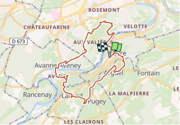
départ Beure

gerardmicheline
User

Length
17.9 km

Max alt
500 m

Uphill gradient
832 m
Km-Effort
29 km

Min alt
231 m

Downhill gradient
832 m
Boucle
Yes
Creation date :
2025-01-05 15:44:16.393
Updated on :
2025-01-05 15:47:10.792
6h35
Difficulty : Very difficult

FREE GPS app for hiking
 SityTrail
IGN / Geographical institutes
SityTrail Plus
The world is yours!
About
Trail Walking of 17.9 km to be discovered at Bourgogne-Franche-Comté, Doubs, Beure. This trail is proposed by gerardmicheline.
Positioning
Country:
France
Region :
Bourgogne-Franche-Comté
Department/Province :
Doubs
Municipality :
Beure
Location:
Unknown
Start:(Dec)
Start:(UTM)
727153 ; 5232305 (31T) N.
Comments