


bruz écluse de mons

Albert lg
User
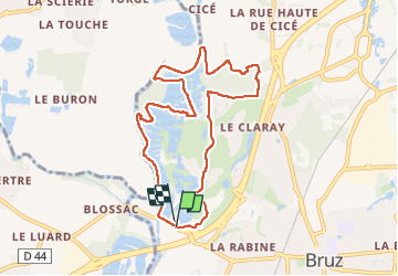

Length
8.6 km

Max alt
34 m

Uphill gradient
51 m
Km-Effort
9.3 km

Min alt
16 m

Downhill gradient
55 m
Boucle
Yes
Creation date :
2025-01-07 13:29:19.351
Updated on :
2025-01-07 15:56:17.614
2h26
Difficulty : Medium

FREE GPS app for hiking
 SityTrail
IGN / Geographical institutes
SityTrail Plus
The world is yours!
About
Trail Walking of 8.6 km to be discovered at Brittany, Ille-et-Vilaine, Bruz. This trail is proposed by Albert lg.
Description
rando
Positioning
Country:
France
Region :
Brittany
Department/Province :
Ille-et-Vilaine
Municipality :
Bruz
Location:
Unknown
Start:(Dec)
Start:(UTM)
591686 ; 5320145 (30U) N.
Comments