


SityTrail - Sorgues Hymalayenne

MicDul
User GUIDE
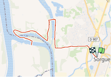

Length
15.4 km

Max alt
35 m

Uphill gradient
122 m
Km-Effort
17 km

Min alt
16 m

Downhill gradient
122 m
Boucle
Yes
Creation date :
2025-01-07 17:29:10.826
Updated on :
2025-01-09 14:43:51.338
4h30
Difficulty : Unknown

FREE GPS app for hiking
 SityTrail
IGN / Geographical institutes
SityTrail Plus
The world is yours!
About
Trail Walking of 15.4 km to be discovered at Provence-Alpes-Côte d'Azur, Vaucluse, Sorgues. This trail is proposed by MicDul.
Photos

Positioning
Country:
France
Region :
Provence-Alpes-Côte d'Azur
Department/Province :
Vaucluse
Municipality :
Sorgues
Location:
Unknown
Start:(Dec)
Start:(UTM)
649845 ; 4874396 (31T) N.
Comments