


Alpilles Aureille opies

taguette
User
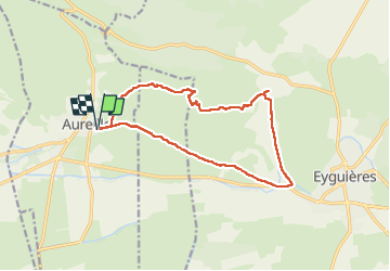

Length
15.3 km

Max alt
479 m

Uphill gradient
434 m
Km-Effort
21 km

Min alt
98 m

Downhill gradient
434 m
Boucle
Yes
Creation date :
2025-01-08 08:04:21.913
Updated on :
2025-01-08 14:32:39.293
6h27
Difficulty : Very difficult

FREE GPS app for hiking
 SityTrail
IGN / Geographical institutes
SityTrail Plus
The world is yours!
About
Trail Walking of 15.3 km to be discovered at Provence-Alpes-Côte d'Azur, Bouches-du-Rhône, Aureille. This trail is proposed by taguette.
Positioning
Country:
France
Region :
Provence-Alpes-Côte d'Azur
Department/Province :
Bouches-du-Rhône
Municipality :
Aureille
Location:
Unknown
Start:(Dec)
Start:(UTM)
657216 ; 4841067 (31T) N.
Comments