


26 - St Vincent la commanderie vallon de Boisse

junique
User
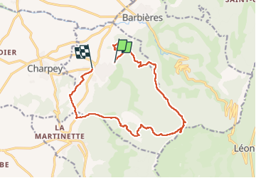

Length
16.2 km

Max alt
1106 m

Uphill gradient
812 m
Km-Effort
27 km

Min alt
341 m

Downhill gradient
865 m
Boucle
No
Creation date :
2025-01-08 07:54:21.834
Updated on :
2025-01-08 14:37:44.589
4h54
Difficulty : Difficult

FREE GPS app for hiking
 SityTrail
IGN / Geographical institutes
SityTrail Plus
The world is yours!
About
Trail Walking of 16.2 km to be discovered at Auvergne-Rhône-Alpes, Drôme, Saint-Vincent-la-Commanderie. This trail is proposed by junique.
Positioning
Country:
France
Region :
Auvergne-Rhône-Alpes
Department/Province :
Drôme
Municipality :
Saint-Vincent-la-Commanderie
Location:
Unknown
Start:(Dec)
Start:(UTM)
667816 ; 4978564 (31T) N.
Comments