


belle rando au dessus du village minier de graissessac

jeff2
User
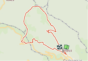

Length
11.1 km

Max alt
1011 m

Uphill gradient
695 m
Km-Effort
20 km

Min alt
332 m

Downhill gradient
695 m
Boucle
Yes
Creation date :
2025-01-09 08:59:08.789
Updated on :
2025-01-09 14:38:49.898
5h03
Difficulty : Medium

FREE GPS app for hiking
 SityTrail
IGN / Geographical institutes
SityTrail Plus
The world is yours!
About
Trail Walking of 11.1 km to be discovered at Occitania, Hérault, Graissessac. This trail is proposed by jeff2.
Description
Magnifique balade en montagne avec un bon dénivelé pour reprendre 2025
Photos


22 photos in total. Please click on a photo to see them all in the gallery.
Positioning
Country:
France
Region :
Occitania
Department/Province :
Hérault
Municipality :
Graissessac
Location:
Unknown
Start:(Dec)
Start:(UTM)
507120 ; 4836622 (31T) N.
Comments
Merci pour ces partages.