


0701

maxEA65
User
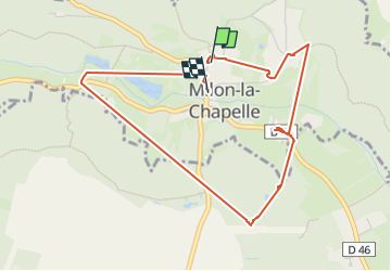

Length
4.4 km

Max alt
167 m

Uphill gradient
104 m
Km-Effort
5.8 km

Min alt
86 m

Downhill gradient
116 m
Boucle
Yes
Creation date :
2025-01-10 07:55:51.002
Updated on :
2025-01-10 09:19:56.181
1h23
Difficulty : Easy

FREE GPS app for hiking
 SityTrail
IGN / Geographical institutes
SityTrail Plus
The world is yours!
About
Trail Walking of 4.4 km to be discovered at Ile-de-France, Yvelines, Milon-la-Chapelle. This trail is proposed by maxEA65.
Positioning
Country:
France
Region :
Ile-de-France
Department/Province :
Yvelines
Municipality :
Milon-la-Chapelle
Location:
Unknown
Start:(Dec)
Start:(UTM)
430091 ; 5397642 (31U) N.
Comments