


JoreauVert

patrando49
User
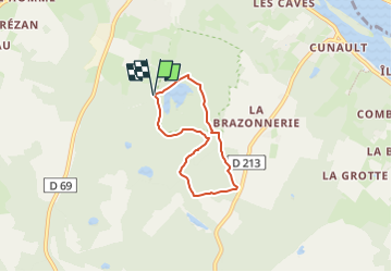

Length
4.6 km

Max alt
85 m

Uphill gradient
35 m
Km-Effort
5.1 km

Min alt
64 m

Downhill gradient
36 m
Boucle
Yes
Creation date :
2025-01-10 21:25:26.184
Updated on :
2025-01-17 14:58:18.524
1h08
Difficulty : Easy

FREE GPS app for hiking
 SityTrail
IGN / Geographical institutes
SityTrail Plus
The world is yours!
About
Trail Walking of 4.6 km to be discovered at Pays de la Loire, Maine-et-Loire, Gennes-Val-de-Loire. This trail is proposed by patrando49.
Positioning
Country:
France
Region :
Pays de la Loire
Department/Province :
Maine-et-Loire
Municipality :
Gennes-Val-de-Loire
Location:
Gennes
Start:(Dec)
Start:(UTM)
709356 ; 5244883 (30T) N.
Comments