


des granges de la vallée au refuge du mont thabord

Danielle07
User
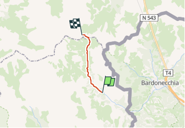

Length
8 km

Max alt
2494 m

Uphill gradient
747 m
Km-Effort
15.5 km

Min alt
1753 m

Downhill gradient
10 m
Boucle
No
Creation date :
2025-01-11 17:00:53.187
Updated on :
2025-06-24 17:28:02.146
3h30
Difficulty : Easy

FREE GPS app for hiking
 SityTrail
IGN / Geographical institutes
SityTrail Plus
The world is yours!
About
Trail On foot of 8 km to be discovered at Provence-Alpes-Côte d'Azur, Hautes-Alpes, Névache. This trail is proposed by Danielle07.
Positioning
Country:
France
Region :
Provence-Alpes-Côte d'Azur
Department/Province :
Hautes-Alpes
Municipality :
Névache
Location:
Unknown
Start:(Dec)
Start:(UTM)
313116 ; 4993307 (32T) N.
Comments