


beauce et eure tt

olivieraron
User
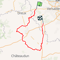

Length
209 km

Max alt
231 m

Uphill gradient
1368 m
Km-Effort
228 km

Min alt
93 m

Downhill gradient
1412 m
Boucle
No
Creation date :
2019-01-14 09:45:37.002
Updated on :
2019-01-14 09:45:37.116
9m
Difficulty : Unknown

FREE GPS app for hiking
 SityTrail
IGN / Geographical institutes
SityTrail Plus
The world is yours!
About
Trail Other activity of 209 km to be discovered at Ile-de-France, Yvelines, Gambais. This trail is proposed by olivieraron.
Positioning
Country:
France
Region :
Ile-de-France
Department/Province :
Yvelines
Municipality :
Gambais
Location:
Unknown
Start:(Dec)
Start:(UTM)
405246 ; 5405825 (31U) N.
Comments