


carbassas

lablaquiere
User
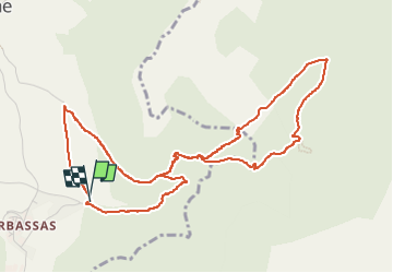

Length
5.8 km

Max alt
819 m

Uphill gradient
336 m
Km-Effort
10.3 km

Min alt
479 m

Downhill gradient
336 m
Boucle
Yes
Creation date :
2025-01-12 09:19:52.349
Updated on :
2025-01-12 11:01:17.978
1h34
Difficulty : Medium

FREE GPS app for hiking
 SityTrail
IGN / Geographical institutes
SityTrail Plus
The world is yours!
About
Trail Walking of 5.8 km to be discovered at Occitania, Aveyron, Paulhe. This trail is proposed by lablaquiere.
Positioning
Country:
France
Region :
Occitania
Department/Province :
Aveyron
Municipality :
Paulhe
Location:
Unknown
Start:(Dec)
Start:(UTM)
508951 ; 4887604 (31T) N.
Comments