


tt

TMGC
User
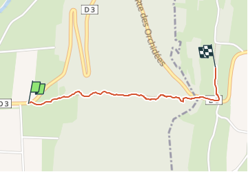

Length
1.2 km

Max alt
537 m

Uphill gradient
202 m
Km-Effort
3.2 km

Min alt
331 m

Downhill gradient
0 m
Boucle
No
Creation date :
2024-12-03 08:27:35.651
Updated on :
2025-01-12 14:59:26.879
39m
Difficulty : Easy

FREE GPS app for hiking
 SityTrail
IGN / Geographical institutes
SityTrail Plus
The world is yours!
About
Trail Walking of 1.2 km to be discovered at Auvergne-Rhône-Alpes, Ain, Nivigne et Suran. This trail is proposed by TMGC.
Positioning
Country:
France
Region :
Auvergne-Rhône-Alpes
Department/Province :
Ain
Municipality :
Nivigne et Suran
Location:
Unknown
Start:(Dec)
Start:(UTM)
687491 ; 5126316 (31T) N.
Comments