


Ramstein vrai BS

bstebe
User
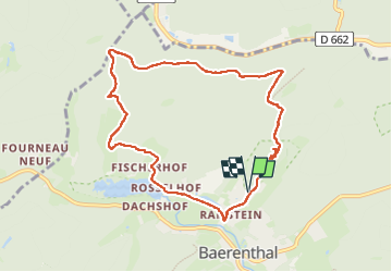

Length
8.8 km

Max alt
352 m

Uphill gradient
247 m
Km-Effort
12.1 km

Min alt
207 m

Downhill gradient
248 m
Boucle
Yes
Creation date :
2025-01-12 12:10:12.534
Updated on :
2025-01-12 15:26:15.526
3h15
Difficulty : Difficult

FREE GPS app for hiking
 SityTrail
IGN / Geographical institutes
SityTrail Plus
The world is yours!
About
Trail Walking of 8.8 km to be discovered at Grand Est, Moselle, Baerenthal. This trail is proposed by bstebe.
Positioning
Country:
France
Region :
Grand Est
Department/Province :
Moselle
Municipality :
Baerenthal
Location:
Unknown
Start:(Dec)
Start:(UTM)
391700 ; 5426476 (32U) N.
Comments