


Chapelle St Pons 171+

claude nier
User
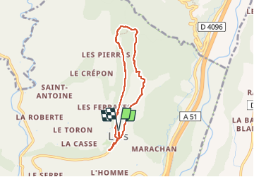

Length
6.6 km

Max alt
606 m

Uphill gradient
171 m
Km-Effort
8.9 km

Min alt
483 m

Downhill gradient
173 m
Boucle
Yes
Creation date :
2025-01-13 07:43:30.517
Updated on :
2025-01-13 12:35:45.144
2h34
Difficulty : Medium

FREE GPS app for hiking
 SityTrail
IGN / Geographical institutes
SityTrail Plus
The world is yours!
About
Trail Walking of 6.6 km to be discovered at Provence-Alpes-Côte d'Azur, Alpes-de-Haute-Provence, Lurs. This trail is proposed by claude nier.
Description
petite rando sympa
Positioning
Country:
France
Region :
Provence-Alpes-Côte d'Azur
Department/Province :
Alpes-de-Haute-Provence
Municipality :
Lurs
Location:
Unknown
Start:(Dec)
Start:(UTM)
731818 ; 4872631 (31T) N.
Comments