


13 janvier 2024

nialaville
User
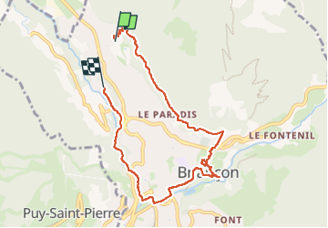

Length
8.4 km

Max alt
1478 m

Uphill gradient
191 m
Km-Effort
11.4 km

Min alt
1205 m

Downhill gradient
320 m
Boucle
No
Creation date :
2025-01-13 10:29:54.0
Updated on :
2025-01-13 15:15:59.56
2h45
Difficulty : Medium

FREE GPS app for hiking
 SityTrail
IGN / Geographical institutes
SityTrail Plus
The world is yours!
About
Trail Walking of 8.4 km to be discovered at Provence-Alpes-Côte d'Azur, Hautes-Alpes, Briançon. This trail is proposed by nialaville.
Positioning
Country:
France
Region :
Provence-Alpes-Côte d'Azur
Department/Province :
Hautes-Alpes
Municipality :
Briançon
Location:
Unknown
Start:(Dec)
Start:(UTM)
312630 ; 4976354 (32T) N.
Comments