


davayat

mouilhaud
User
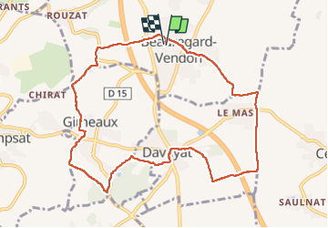

Length
10.3 km

Max alt
425 m

Uphill gradient
142 m
Km-Effort
12.2 km

Min alt
333 m

Downhill gradient
142 m
Boucle
Yes
Creation date :
2025-01-05 13:03:19.491
Updated on :
2025-01-13 17:35:42.999
196h30
Difficulty : Difficult

FREE GPS app for hiking
 SityTrail
IGN / Geographical institutes
SityTrail Plus
The world is yours!
About
Trail Walking of 10.3 km to be discovered at Auvergne-Rhône-Alpes, Puy-de-Dôme, Beauregard-Vendon. This trail is proposed by mouilhaud.
Description
beauregard
Positioning
Country:
France
Region :
Auvergne-Rhône-Alpes
Department/Province :
Puy-de-Dôme
Municipality :
Beauregard-Vendon
Location:
Unknown
Start:(Dec)
Start:(UTM)
508436 ; 5089696 (31T) N.
Comments