


Menthières chalet du sac

loca.yves
User GUIDE
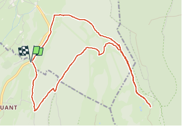

Length
6.3 km

Max alt
1379 m

Uphill gradient
326 m
Km-Effort
10.7 km

Min alt
1074 m

Downhill gradient
326 m
Boucle
Yes
Creation date :
2025-01-14 07:08:09.775
Updated on :
2025-01-14 09:57:15.93
2h48
Difficulty : Medium

FREE GPS app for hiking
 SityTrail
IGN / Geographical institutes
SityTrail Plus
The world is yours!
About
Trail Snowshoes of 6.3 km to be discovered at Auvergne-Rhône-Alpes, Ain, Confort. This trail is proposed by loca.yves.
Description
belle
Photos


Positioning
Country:
France
Region :
Auvergne-Rhône-Alpes
Department/Province :
Ain
Municipality :
Confort
Location:
Unknown
Start:(Dec)
Start:(UTM)
719734 ; 5116613 (31T) N.
Comments