


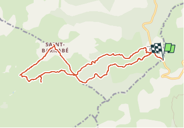
Col de Vence, St Barnabé, Village Nègre

Renefrt
User

Length
11.1 km

Max alt
974 m

Uphill gradient
145 m
Km-Effort
13 km

Min alt
919 m

Downhill gradient
144 m
Boucle
Yes
Creation date :
2025-01-14 12:19:56.0
Updated on :
2025-01-14 12:19:57.911
2h56
Difficulty : Medium

FREE GPS app for hiking
 SityTrail
IGN / Geographical institutes
SityTrail Plus
The world is yours!
About
Trail Walking of 11.1 km to be discovered at Provence-Alpes-Côte d'Azur, Maritime Alps, Vence. This trail is proposed by Renefrt.
Positioning
Country:
France
Region :
Provence-Alpes-Côte d'Azur
Department/Province :
Maritime Alps
Municipality :
Vence
Location:
Unknown
Start:(Dec)
Start:(UTM)
345024 ; 4847158 (32T) N.
Comments
Peu de chemin balisé hormis le GR ne pas avoir peur de sortir de la piste