


circuit anciennes abbayes

jean charles daniel.
User
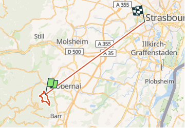

Length
35 km

Max alt
583 m

Uphill gradient
612 m
Km-Effort
43 km

Min alt
136 m

Downhill gradient
818 m
Boucle
No
Creation date :
2025-01-14 08:54:05.712
Updated on :
2025-01-14 15:07:24.403
5h12
Difficulty : Medium

FREE GPS app for hiking
 SityTrail
IGN / Geographical institutes
SityTrail Plus
The world is yours!
About
Trail Walking of 35 km to be discovered at Grand Est, Bas-Rhin, Saint-Nabor. This trail is proposed by jean charles daniel..
Description
dep. Saint Nabor rue des carrières direction truttenhausen
Photos


44 photos in total. Please click on a photo to see them all in the gallery.
Positioning
Country:
France
Region :
Grand Est
Department/Province :
Bas-Rhin
Municipality :
Saint-Nabor
Location:
Unknown
Start:(Dec)
Start:(UTM)
383217 ; 5367128 (32U) N.
Comments
rando panoramique