


2025-01-14

rando30129
User
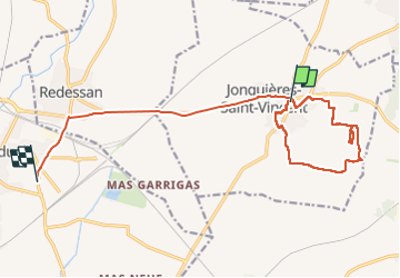

Length
16.5 km

Max alt
67 m

Uphill gradient
146 m
Km-Effort
18.4 km

Min alt
18 m

Downhill gradient
121 m
Boucle
No
Creation date :
2025-01-14 12:27:49.054
Updated on :
2025-01-14 15:54:12.692
2h59
Difficulty : Difficult

FREE GPS app for hiking
 SityTrail
IGN / Geographical institutes
SityTrail Plus
The world is yours!
About
Trail Walking of 16.5 km to be discovered at Occitania, Gard, Jonquières-Saint-Vincent. This trail is proposed by rando30129.
Positioning
Country:
France
Region :
Occitania
Department/Province :
Gard
Municipality :
Jonquières-Saint-Vincent
Location:
Unknown
Start:(Dec)
Start:(UTM)
625753 ; 4854138 (31T) N.
Comments