


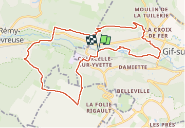
Gif Saint-Rémy Boucle

CIE NPS
User

Length
11 km

Max alt
168 m

Uphill gradient
224 m
Km-Effort
14 km

Min alt
62 m

Downhill gradient
225 m
Boucle
Yes
Creation date :
2025-01-14 12:46:12.0
Updated on :
2025-01-14 15:56:43.594

FREE GPS app for hiking
 SityTrail
IGN / Geographical institutes
SityTrail Plus
The world is yours!
About
Trail of 11 km to be discovered at Ile-de-France, Essonne, Gif-sur-Yvette. This trail is proposed by CIE NPS.
Description
Gif Saint-Rémy Boucle
Positioning
Country:
France
Region :
Ile-de-France
Department/Province :
Essonne
Municipality :
Gif-sur-Yvette
Location:
Unknown
Start:(Dec)
Start:(UTM)
434085 ; 5394700 (31U) N.
Comments