


Cézas B

ARVIEU
User
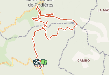

Length
13.8 km

Max alt
877 m

Uphill gradient
540 m
Km-Effort
21 km

Min alt
614 m

Downhill gradient
541 m
Boucle
Yes
Creation date :
2015-06-10 00:00:00.0
Updated on :
2015-06-10 00:00:00.0
4h28
Difficulty : Easy

FREE GPS app for hiking
 SityTrail
IGN / Geographical institutes
SityTrail Plus
The world is yours!
About
Trail Walking of 13.8 km to be discovered at Occitania, Gard, Sumène. This trail is proposed by ARVIEU.
Description
de Cézas à St Roman de Codières A-R
Positioning
Country:
France
Region :
Occitania
Department/Province :
Gard
Municipality :
Sumène
Location:
Unknown
Start:(Dec)
Start:(UTM)
562426 ; 4869435 (31T) N.
Comments