


La Scia

oliviergau
User
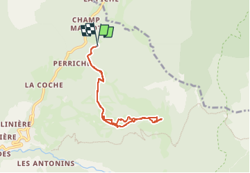

Length
7 km

Max alt
1705 m

Uphill gradient
575 m
Km-Effort
14.6 km

Min alt
1123 m

Downhill gradient
577 m
Boucle
Yes
Creation date :
2025-01-15 08:39:14.37
Updated on :
2025-01-15 11:23:36.787
2h43
Difficulty : Very easy

FREE GPS app for hiking
 SityTrail
IGN / Geographical institutes
SityTrail Plus
The world is yours!
About
Trail Touring skiing of 7 km to be discovered at Auvergne-Rhône-Alpes, Isère, Saint-Pierre-de-Chartreuse. This trail is proposed by oliviergau.
Positioning
Country:
France
Region :
Auvergne-Rhône-Alpes
Department/Province :
Isère
Municipality :
Saint-Pierre-de-Chartreuse
Location:
Unknown
Start:(Dec)
Start:(UTM)
721859 ; 5026618 (31T) N.
Comments