


Taberg

Benteux
User

Length
16.9 km

Max alt
49 m

Uphill gradient
132 m
Km-Effort
18.6 km

Min alt
-1 m

Downhill gradient
134 m
Boucle
Yes
Creation date :
2015-06-10 00:00:00.0
Updated on :
2015-06-10 00:00:00.0
6h15
Difficulty : Easy

FREE GPS app for hiking
 SityTrail
IGN / Geographical institutes
SityTrail Plus
The world is yours!
About
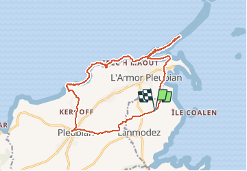
Trail Walking of 16.9 km to be discovered at Brittany, Côtes-d'Armor, Lanmodez. This trail is proposed by Benteux.
Photos

Positioning
Country:
France
Region :
Brittany
Department/Province :
Côtes-d'Armor
Municipality :
Lanmodez
Location:
Unknown
Start:(Dec)
Start:(UTM)
492777 ; 5410653 (30U) N.
Comments
Le départ de cette rando est surprenant. Sinon magnifique sur le littoral et le sillon du talbert