


Monteras fait 2025

pidjam
User

Length
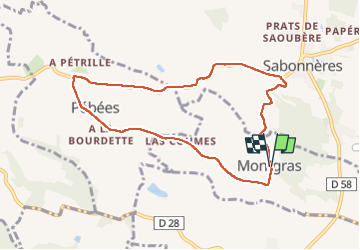
8.6 km

Max alt
300 m

Uphill gradient
156 m
Km-Effort
10.7 km

Min alt
213 m

Downhill gradient
157 m
Boucle
Yes
Creation date :
2025-01-16 13:23:10.689
Updated on :
2025-01-16 15:50:02.599
2h06
Difficulty : Easy

FREE GPS app for hiking
 SityTrail
IGN / Geographical institutes
SityTrail Plus
The world is yours!
About
Trail Walking of 8.6 km to be discovered at Occitania, Haute-Garonne, Montgras. This trail is proposed by pidjam.
Positioning
Country:
France
Region :
Occitania
Department/Province :
Haute-Garonne
Municipality :
Montgras
Location:
Unknown
Start:(Dec)
Start:(UTM)
342820 ; 4812970 (31T) N.
Comments