


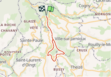
Le Saule d’Oingt (10 km - D. 252 m)

Thomasdanielle
User

Length
10.1 km

Max alt
650 m

Uphill gradient
252 m
Km-Effort
13.5 km

Min alt
491 m

Downhill gradient
248 m
Boucle
Yes
Creation date :
2025-01-16 13:07:16.0
Updated on :
2025-02-26 13:10:46.696
3h03
Difficulty : Difficult

FREE GPS app for hiking
 SityTrail
IGN / Geographical institutes
SityTrail Plus
The world is yours!
About
Trail Walking of 10.1 km to be discovered at Auvergne-Rhône-Alpes, Rhône, Ville-sur-Jarnioux. This trail is proposed by Thomasdanielle.
Description
Parking :
Positioning
Country:
France
Region :
Auvergne-Rhône-Alpes
Department/Province :
Rhône
Municipality :
Ville-sur-Jarnioux
Location:
Unknown
Start:(Dec)
Start:(UTM)
622576 ; 5093004 (31T) N.
Comments