


Mt Vinaigre

aljac
User
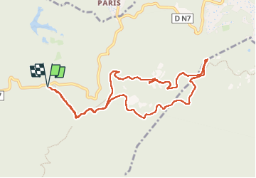

Length
10.8 km

Max alt
600 m

Uphill gradient
355 m
Km-Effort
15.6 km

Min alt
317 m

Downhill gradient
355 m
Boucle
Yes
Creation date :
2025-01-17 08:22:35.475
Updated on :
2025-01-17 13:08:54.719
4h45
Difficulty : Easy

FREE GPS app for hiking
 SityTrail
IGN / Geographical institutes
SityTrail Plus
The world is yours!
About
Trail Walking of 10.8 km to be discovered at Provence-Alpes-Côte d'Azur, Var, Fréjus. This trail is proposed by aljac.
Positioning
Country:
France
Region :
Provence-Alpes-Côte d'Azur
Department/Province :
Var
Municipality :
Fréjus
Location:
Unknown
Start:(Dec)
Start:(UTM)
321732 ; 4818846 (32T) N.
Comments