


AYNÉ G3

LouisROGER
User GUIDE
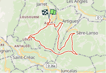

Length
10 km

Max alt
876 m

Uphill gradient
412 m
Km-Effort
15.5 km

Min alt
586 m

Downhill gradient
410 m
Boucle
Yes
Creation date :
2025-01-17 08:26:20.284
Updated on :
2025-01-17 14:15:58.953
5h49
Difficulty : Difficult

FREE GPS app for hiking
 SityTrail
IGN / Geographical institutes
SityTrail Plus
The world is yours!
About
Trail Walking of 10 km to be discovered at Occitania, Hautespyrenees, Jarret. This trail is proposed by LouisROGER.
Positioning
Country:
France
Region :
Occitania
Department/Province :
Hautespyrenees
Municipality :
Jarret
Location:
Unknown
Start:(Dec)
Start:(UTM)
743416 ; 4773594 (30T) N.
Comments